14 August 2021 - Sat
Rain falls on Greenland for the first time
For the first time in recorded history, rain has fallen on the peak of Greenland ice cap. It is an extremely urgent and ominous warning of climate change. At this altitude of 3216 metres, temperatures are normally well below freezing. Scientists were surprised by the rainfall as such an event had no precedent on record.
17 August 2021 - Tue
Widespread rain and melt for 3 days
Temperatures were 18°C higher than average in Greenland over the past 3 days and an estimated 7 billion tonnes of rain has fallen across the Greenland ice sheet. As a result, widespread surface melting – across an area about 4 times the size of the UK – and high runoff volumes to the ocean occurred.
Greenland also had a large-scale melting episode in July. The rain and melt on 14-16 August made the situation even more dire for 2021.
In May, researchers had already warned that a significant part of the Greenland ice sheet was nearing a tipping point, after which accelerated melting would become inevitable even if global heating was halted.
21 August 2021 - Sat
Kyrios hears about the news
Alarmed at the news of rain falling on Greenland's peak, Kyrios quickly surveys the conditions in Greenland to examine the extent of melting. Kyrios comments that rain at Greenland will lead to very serious consequences for the region, hence immediate intervention is necessary.
23 August 2021 - Mon
⭐️ Kyrios begins restoring ice in the Arctic
Kyrios sets out to create favourable climatic conditions for increasing ice volumes in the Arctic region. Immediate attention was on Greenland given its urgent situation. The geographical region of Kyrios' intervention also includes countries in and around the Arctic Circle, such as Alaska, Canada, northern United States, Siberia, and even northern China. This intervention will continue until March 2022.
Kyrios says that the northern hemisphere will experience colder winters this year due to the intervention.
31 August 2021 - Tue
Rate of loss in Arctic sea ice volume slows down
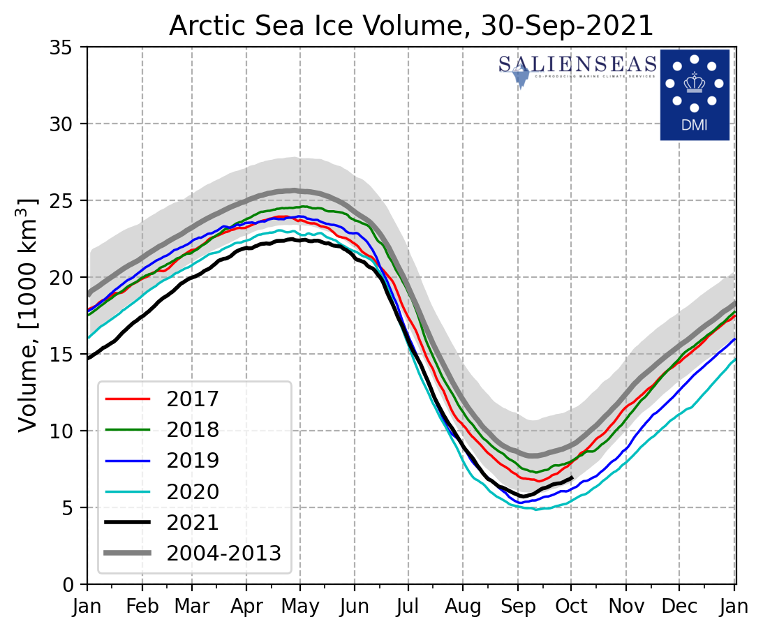
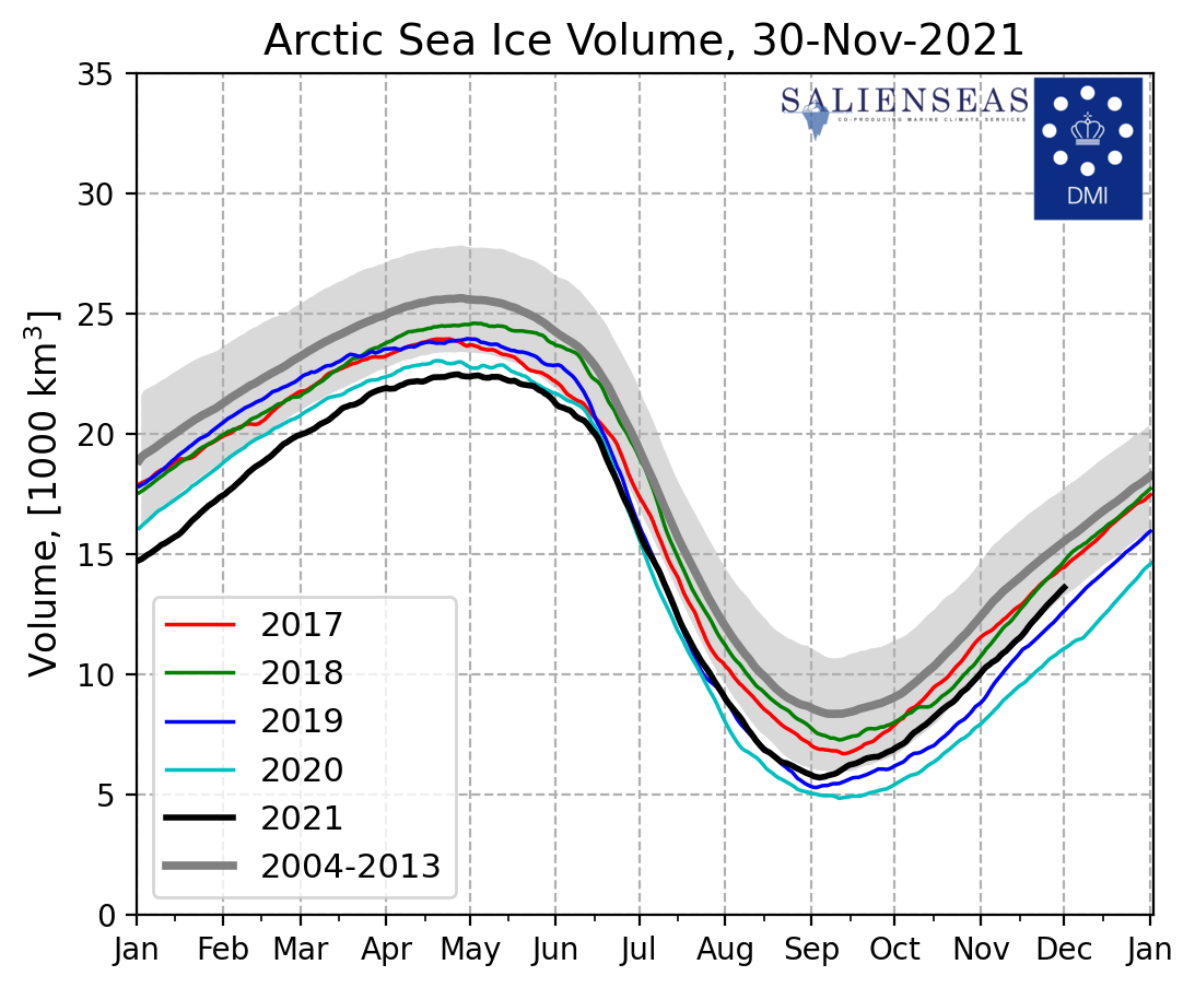
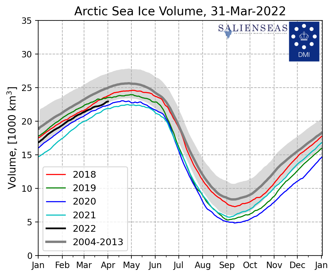
The downward trend of the average Arctic sea ice volume as the years go by is a powerful evidence of rising global temperatures. Data from the Danish Meteorological Institute shows that ice volume in the Arctic sea in 2021 started off as being the lowest in recent years and throughout the first half of 2021. It was highly possible that Arctic sea ice volume could remain being the lowest in 2021 and set another year of record low.
Remarkably, after Kyrios' intervention on 23 Aug, the graph shows that the rate of loss in sea ice volume has begun to slow down, as illustrated by the gentler downward curve towards the end of Aug. The 2021 line has also started to pull away from 2019 and 2020, signifying that a change in the year-on-year downward trend is underway.
12 September 2021 - Sun
A rare hurricane specially delivers snow to Greenland
3 weeks after Kyrios began intervention, an unusual hurricane, named Larry, brought a significant amount of snowfall to Greenland. It first developed off the west coast of Africa on 31 Aug and trekked far across the Atlantic ocean. The hurricane made a landfall in Newfoundland on 11 Sep before heading for its final destination – Greenland. It is very rare that a hurricane sustains so far north in the Atlantic and pushes high tropical moisture towards the Arctic region.
Hurricane Larry morphed from a warm-core tropical hurricane to a cold-core extratropical storm, which enhanced precipitation, as it approached Greenland. Its moisture eventually fell as snow over Greenland, prompting people to call it a "Snowicane". This is only the 5th time in recorded history that a hurricane ended up unleashing snow.
Gary Partyka, a senior scientist at NASA, said that hurricanes cannot propel themselves, "they need to be steered by larger-scale pressure patterns in the atmosphere. These steering currents were oriented more north-south than usual", leading to Larry moving northwards towards the Arctic. Larry's steering pattern, along with the higher-than-usual sea surface temperatures in the Atlantic, allowed it to survive longer as a warm-core hurricane and retain tropical moisture.
13 September 2021 - Mon
Larry replenished melt losses from summer
The snowfall brought in by Hurricane Larry has been so abundant that it is estimated that Larry could potentially balance out losses from melting during the summer, which included three notable melting events – two in July and one in August.
Danish research institutions suggest that Larry may have dropped 10 gigatons of snow on Greenland on Sunday while computer models estimate that parts of Greenland saw approximately two to three feet of snow.
Lauren Andrews, a glaciologist with NASA said, "It is a dramatic end to a season of extreme events across the Greenland ice sheet," noting also that it is unusual to see such a high rate of snowfall so soon after the end of the summer melt season, which occurs each year from around May to early September.
⭐️ Kyrios explains about the Larry phenomenon
Back in early July 2021, Kyrios had predicted that two hurricanes would form in the Atlantic Ocean between September to October, and one of them would hit the east coast of the U.S. A year ago in 2020, Kyrios had also envisioned that a white Cathedral near the coast would be destroyed by a storm surge.
Hence, in a fortuitous moment in August, as Hurricane Larry was establishing in the Atlantic Ocean, Kyrios saw not only an opportunity to leverage Larry to replenish ice in Greenland, but also to steer the hurricane away from the U.S. East Coast.
Kyrios explains that it is not easy to maintain the favourable conditions that allowed the hurricane to sustain its strength and capture even more moisture along the way to Greenland.
Finally, as the hurricane approached Greenland, Kyrios then acted to convert the moisture into snow, by "pushing" the hurricane high up into the atmosphere, where it would interact with cold currents to form atmospheric ice, which would then fall as snow.
16 September 2021 - Thu
Sea ice "shrank less in 2021", and reaches minimum extent – highest since 2014
Sea ice reached its minimum extent on this day, which is the 12th lowest on record, but highest since 2014.
Scientists with the National Snow and Ice Data Centre (NSIDC) said that, as summer was ending in the Northern Hemisphere, Arctic sea ice had shrunk less in 2021 than in other recent years. Mark Serreze, Director of NSIDC also commented that, "We had a reprieve this year — a cool and stormy summer with less ice melt."
This is great news, because it means that Kyrios' intervention is impactful, and showing real improvements to ice conditions in the Arctic. In addition to restoring ice, Kyrios also wanted to retain as much ice during the summer season, so this was an important milestone. This would also mean that Kyrios' efforts to raise ice extent during winter would produce greater results.
However, NSIDC cautioned that the Arctic Sea ice extent figures were preliminary, that the trend may reverse as continued melting could still push the ice minimum extent lower before the early winter freeze begins. Kyrios will continue to monitor the situation and intervene if necessary.
30 September 2021 - Thu
September sea ice extent increased 25% year-on-year!
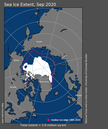
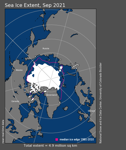
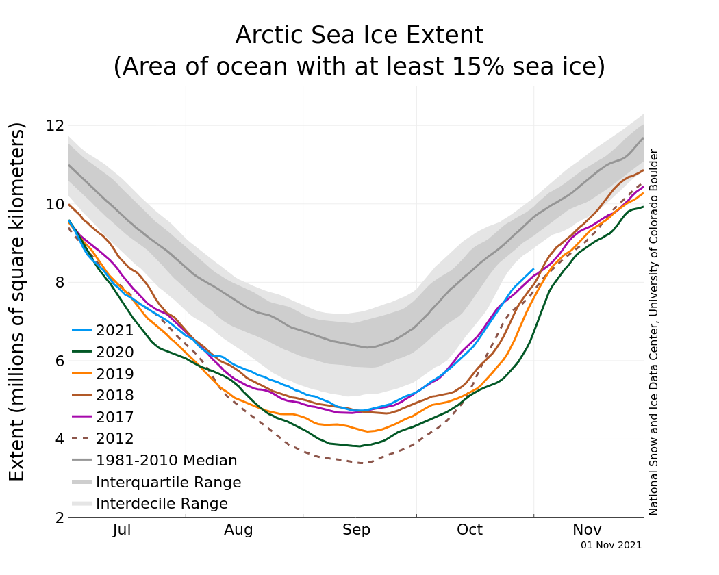
At the end of September, one and a half months after Kyrios started intervention, sea ice extent reached 4.9 million sq km compared with only 3.9 million sq km in 2020.
Sea ice volume reached normal range
The graph above shows that sea ice volume began to increase earlier in Sep 2021 compared to recent years. The sea ice volume has also reached within the 2004-2013 interdecile range for the first time this year.
17 October 2021 - Sun
China starts experiencing winter conditions even before winter season
Just as Kyrios forewarned when intervention began in August, that many countries in the Northern Hemisphere, especially those near and around the Arctic Circle, will experience colder winters this year due to the intervention, Beijing, China, was reported to have ushered in a "quick-freeze" weather in the middle of October. Temperatures in many parts of Beijing, China, fell below the freezing point more than half a month earlier than normal – the lowest value recorded in 52 years.
A cold wave chilled eastern and central China, possibly foretelling a colder-than-average winter. An expert said that the cold wave was caused by the westerly, which brings cold and dry air from Siberia to China. The pattern repeats every year but came earlier this year amid atmospheric circulation anomalies.
28 October 2021 - Thu
Early snowfall in parts of U.S. while other parts experienced higher temperatures
California ski resorts open early compared to previous years due to early snowfall.
31 October 2021 - Sun
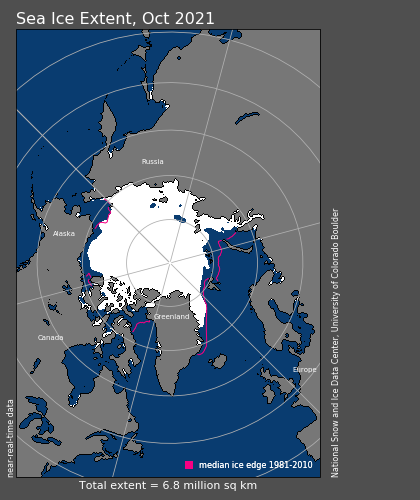
October sea ice extent grew by close to 100,000 sq km per day and increased 30% year-on-year!
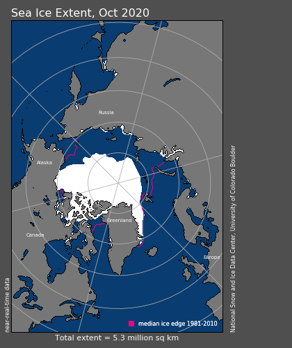
Ice extent is 6.8 million sq km in 2021 compared with 5.3 million in 2020.
As of October 31, sea ice extent is tracking higher than any year since 2015, as well as higher than observed in 2007, 2011, and 2012.
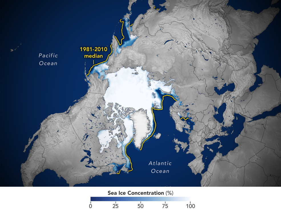
Average monthly air temperatures were well below freezing across much of the Arctic Ocean in October. Overall, ice extent increased by close to 100,000 sq km per day during the month of October. This rate of increase was larger than the 1981 to 2010 average of 89,200 sq km per day. Sea ice extent has grown at such an incredible pace throughout October that large parts of the remote Arctic waters along the Russian coast have become covered with sea ice, complicating shipping conditions.
Sea ice volume continues to stay near interdecile range
Arctic sea ice volume continues to grow steadily and stayed near the 2004-2013 interdecile range throughout October 2021, contrasting the situation seen in the past 2 years.
1 November 2021 - Mon
In Canada, snowfall usually occurs between December to March, but in 2021, some areas have experienced snowfall in November, and some even as early as September.
2 November 2021 - Tue
Ice maps show that major parts of the Laptev Sea and the East Siberian Sea are covered by sea ice that is more than 15cm thick. In the eastern parts of the East Siberian Sea are areas with up to 70cm thick one-year ice, as well as 2m thick multi-year ice.
20 November 2021 - Sat
Kyrios' Antarctic intervention begins!
As an expansion of Kyrios' ongoing endeavour to save our Earth's polar ice and curb rising sea levels, Kyrios announces that efforts to restore ice in the Antarctic had begun and will continue till November 2022.
This will be Kyrios' most difficult and challenging climate crisis intervention to date!! Stay updated about the Antarctic intervention here.
30 November 2021 - Tue
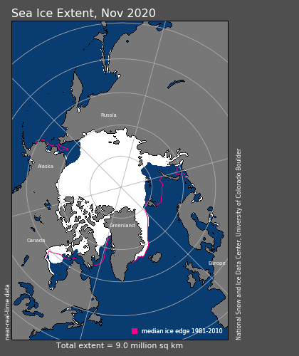
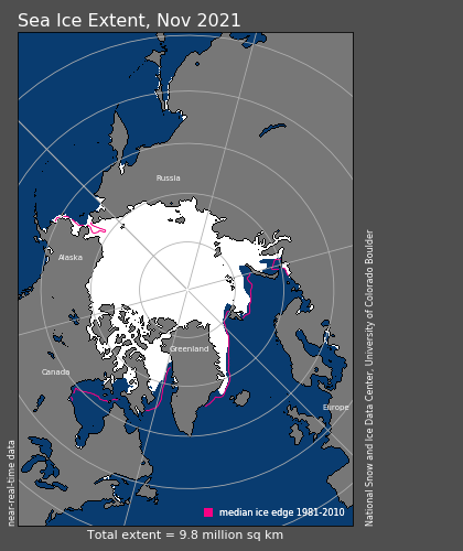
November sea ice extent increased 10% year-on-year
Sea ice extent is at 9.8 million sq km, compared to 9.0 million sq km in 2020. The ice froze at a faster than average pace through November.
Unforeseen early freeze of the Northern Sea Route
Ships transiting along the Northern Sea route were unexpectedly stuck as ice conditions in late October and early November over the past years have allowed extensive shipping along the vast Russian Arctic coast. As many as 24 ships became frozen in and had to await icebreakers to break through the 30 cm thick ice to make way for escape.
Russian officials had earlier forecasted and announced that the route would remain open for the entire month of November. Therefore, much to their surprise — and dismay – the shipping route had already frozen up by October this year and the route had to be closed early. Officials said that it was the first time in the last 7 years that the sea ice had already frozen so much by this time — ice had formed two weeks earlier than seen in the previous 7 years. Alexei Likhachyov, the director general of Rosatom, a company that runs a fleet of nuclear-powered icebreaker ships, said that "weather forecasts were inaccurate."
This further corroborates that Kyrios' intervention has indeed altered this year's Arctic weather.
Strange phenomenon observed by Russian meteorologists
What's even more interesting and noteworthy is that the early freeze happened despite the extraordinarily warm weather of October. While temperature maps from the Russian meteorological service showed that major parts of the Russian Arctic coast were 2-4°C warmer than normal in October, strong winds were also detected in the region. In the first week of November, storms with gusts up to 30 m/s raged across the area. The strong winds may have helped ice to form despite the higher temperature.
Sea ice volume continues to stay near interdecile range
The steep upward growth trajectory of Arctic sea ice volume continues through November and although it is still at the lower end of the 2004-2013 interdecile range, we must not forget that it is already a phenomenal feat that Kyrios has actually reversed the downward year-on-year trend of sea ice volume that is set by the past 2 years of 2019 and 2020.
10 December 2021 - Fri
Strong polar vortex causes deep freeze in high latitudes amid record-breaking warmth
Washington Post – A strong polar vortex over the Arctic has brought sub-zero cold to Siberia, Scandinavia and Alaska. In late November and early December, many parts of the Lower 48 states of the U.S. and other locations in the mid-latitudes have experienced record-breaking warmth. But incredible cold has infiltrated areas nearer to the Arctic.
Frigid weather, tens of degrees below zero, has invaded northeast Russia, Scandinavia, Alaska and northern Canada in recent weeks. The cold is related to an unusually strong polar vortex that has trapped bone-chilling air over the high latitudes, allowing little of it to escape to the south.
While the exceptional cold is occurring in some of the planet's fastest-warming areas, it does not counter the ongoing rapid climate change. Rather, it shows how weather patterns can arrange themselves to produce rather dramatic extremes.
28 December 2021 - Wed
Western US states and Canada hit by record freeze and heavy snow
The US west is facing record-breaking cold temperatures and heavy snow as severe weather sweeps the region from Washington to California amid an arctic blast that forecasters said would last several days. Low temperatures in Seattle reached -6.7°C, breaking a mark set in 1948. Snow showers dumped up to 15 cm of snow across the area. Bellingham, Washington, was -12.8°C, 1.7°C degrees colder than the previous record set in 1971. At Donner Pass in the Sierra, recent snowfall had smashed the snowiest December record of 4.6 metres, set in 1970. The record is now 4.9 metres, and more snow is expected.
In Western Canada, record-low temperatures were recorded in 43 communities across Alberta and B.C. between Sunday and Monday. The coldest community was Grande Prairie, Alta., which saw temperatures plummet to -44.4°C, beating the record set in 1984. That's -56°C with the wind chill.
31 December 2021 - Fri
Year-End Review - 2021 Arctic sea ice extent the fastest-growing and highest in recent years!
Almost 5 months into Kyrios' intervention, against the backdrop of a warming Arctic region, Kyrios' efforts to restore ice in the Arctic continues to progress with encouraging results.
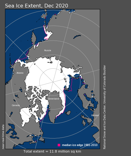
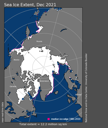
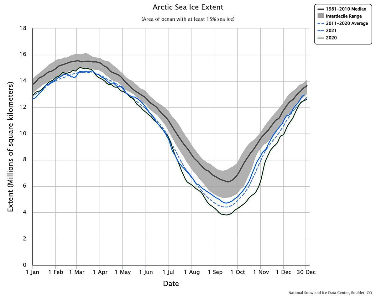
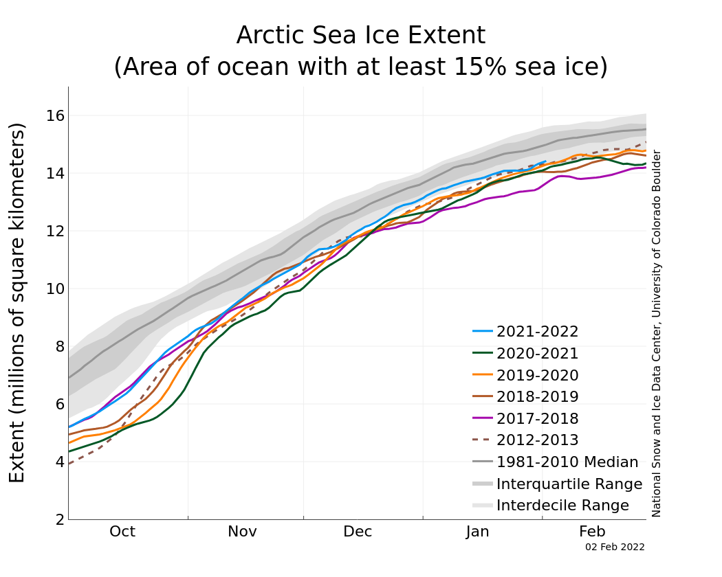
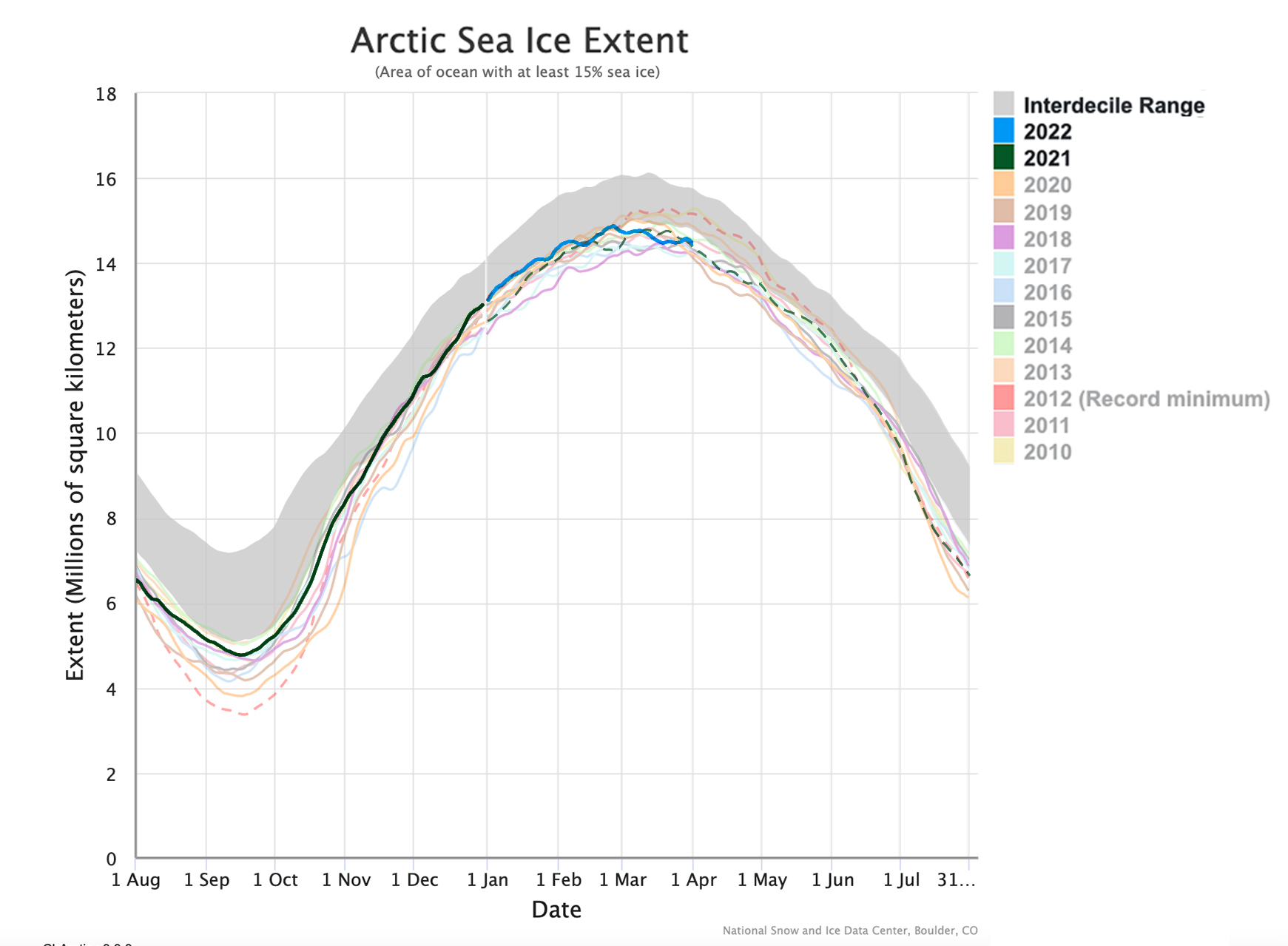
According to a detailed year-end review by Severe Weather Europe, Arctic sea ice extent at the end of December 2021 is at 12.95 million sq km – the highest in 7 years and the 2nd highest in 18 years. Ice extent also grew faster than in recent years. The ice extent has reached the 1981-2010 interdecile range in December, which means it is within the normal sea-ice inter-annual variability, a situation that's not been seen since 2014.
Sea ice reportedly grew "unusually" fast in December in the Greenland Sea, the Sea of Okhotsk, and the Hudson Bay, and is much higher than average in the Greenland Sea and in the Sea of Okhotsk.
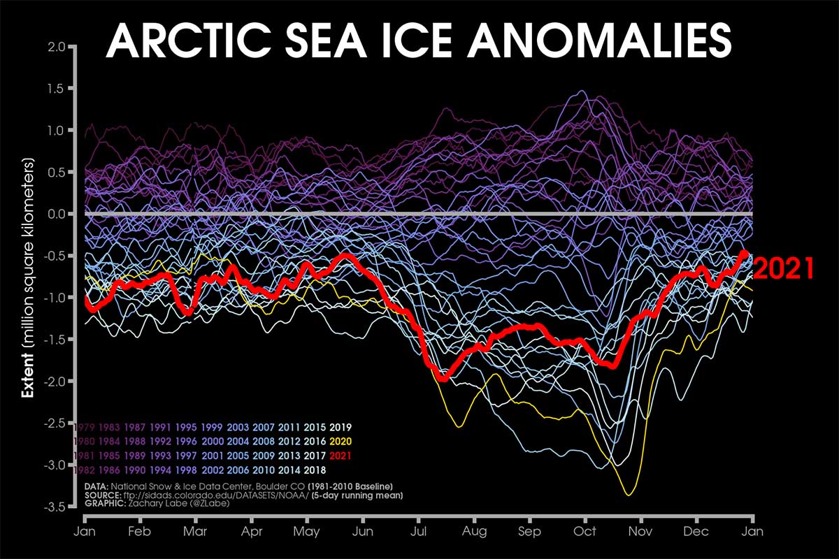
As shown in the image below, sea ice extent in 2021 remained consistently above the 2011-2020 average from August – when Kyrios began to intervene.
The review also pointed out that after the rapid melting from late May to early July, Arctic sea ice anomalies has been in a positive phase as anomalies were reduced through August and over the last 5 months.
Colder-than-normal weather phenomenon had triggered fast and earlier freezing
In 2021, sea ice reached its minimum extent on September 16th, which was the 12th lowest on record, but highest since 2014. The main reason given was that "colder than average weather in the western Arctic Ocean slowed down sea ice from melting in the Canadian and Alaskan regions".
The article described that "a northern hemisphere's strong negative height anomaly in the geopotential in late summer kept the western Arctic cooler and reduced the ice from melting". Not only was air temperature colder than normal, but sea temperature as well – a "favourable trigger" contributing to fast and earlier freezing in this Arctic sector when the fall season started.
2021 sea ice extent growth contradicts what is happening globally and in the Antarctic
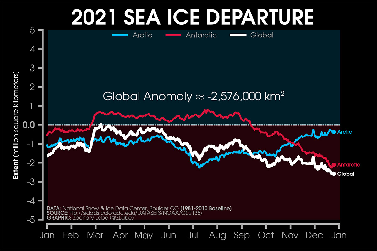
Finally, the article also noted that the sea ice extent in the Arctic this year contrasts with what is happening globally, particularly in the Antarctic where sea ice is in sharp decline. Although stable above the long-term average from March to the end of August, Antarctic sea ice began its rapid decline in September.
Hopefully, Kyrios' endeavour to bolster the Antarctic glaciers will bear fruit in 2022.
December sea ice volume moves higher within interdecile range
Since Kyrios began intervention, the Arctic ice has been seeing positive news. December sea ice volume has risen even higher within the 2004-2013 interdecile range. For the past 2 years, during the second half of the year, Arctic sea ice volume has been low and outside of the interdecile range, while 2021 has mostly maintained within range.
Implications for global climate
Sea ice extent in the Arctic has important implications for global climate and weather, especially in North America and Europe. For this winter season, the Arctic sea ice extent has been increasing at a steady pace as part of Kyrios' intervention, and if this trend continues in the coming months, there may be important repercussions for next spring's synoptic and meteorological conditions. For example, a study has found that diminished sea ice in the Arctic is closely tied to wetter summers in northern Europe. Scientists have also warned of the risk of the gulf stream collapsing due to increased freshwater from ice melt, which will impact the climate of countries in the northern hemisphere.
31 January 2022 - Mon
Largest January sea ice extent achieved since 2009
Arctic sea ice extent in January was the largest since 2009, reaching 14.0 million km2. Although it was 1% (0.1 million km2) below the 1991-2020 average, it was a significant positive development considering sea ice extent levels have been on a declining trend. January 2022 finished as the sixteenth lowest extent in the satellite record.
Sea ice volume continues to remain higher than 2020 and 2021 and is still well within the 2004-2013 interdecile range.
28 February 2022 - Mon
Sea ice extent has been volatile, but sea ice volume remained well within interdecile range
Against the backdrop of high carbon emissions in the atmosphere, Kyrios' intervention to boost Arctic ice this winter has not only kept sea ice well above the recent 2010s average for most of the winter, the intervention also prevented sea ice extent from shrinking to extreme low averages.
February Arctic sea ice extent was only 2% (0.3 million km2) below the 1991-2020 average. It did not fall to extremely low extents like that of July 2021, which was prior to intervention and 2nd lowest July extent on record. The smallest February extent occurred in 2018 and was significantly smaller than 2022's, at almost 6% below average.
Sea ice volume continues to rise steadily, remaining higher than 2020 and 2021 and well within the 2004-2013 interdecile range.
14 March 2022 - Mon
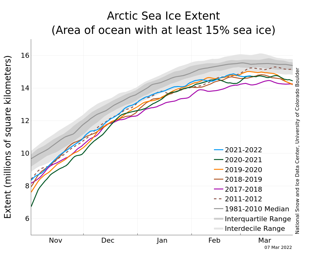
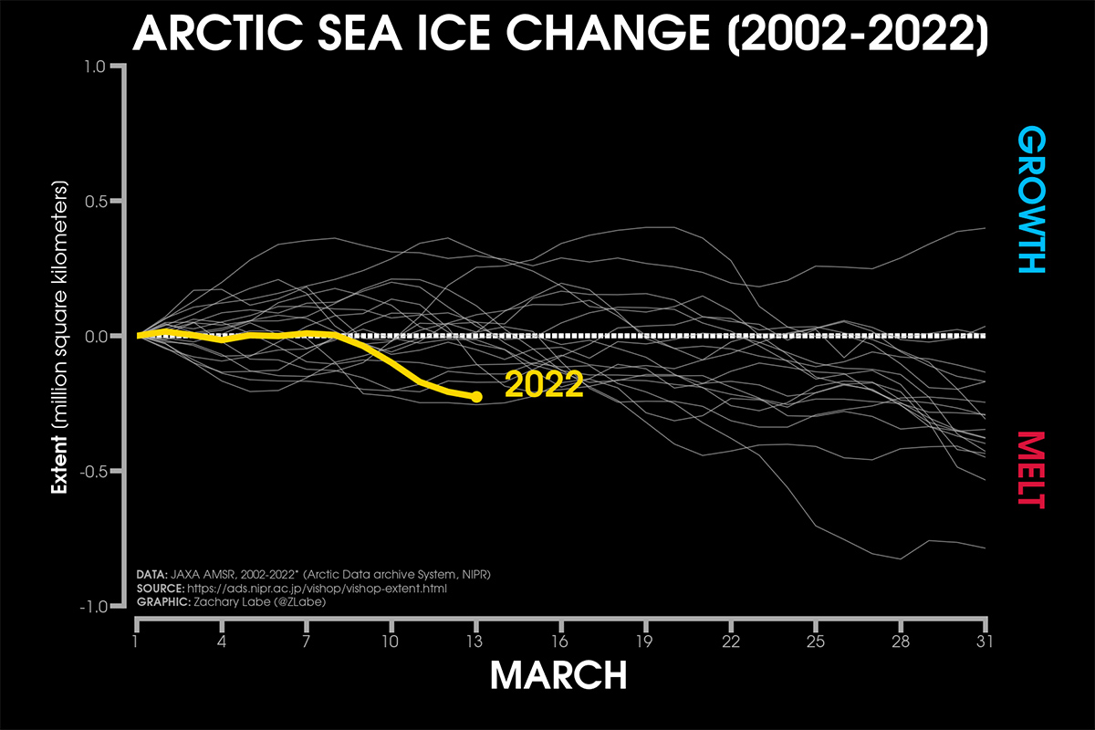
Sea ice cover in the Arctic grows throughout the winter and peaks in March. Throughout this whole winter season, Arctic sea ice extent has been well within the interdecile range and has grown at a decent rate. After being perfectly aligned to the last twenty years average during the first half of March 2022, an abrupt sea ice extent decline began on the 8th.
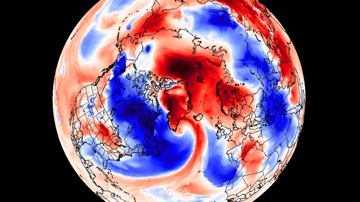
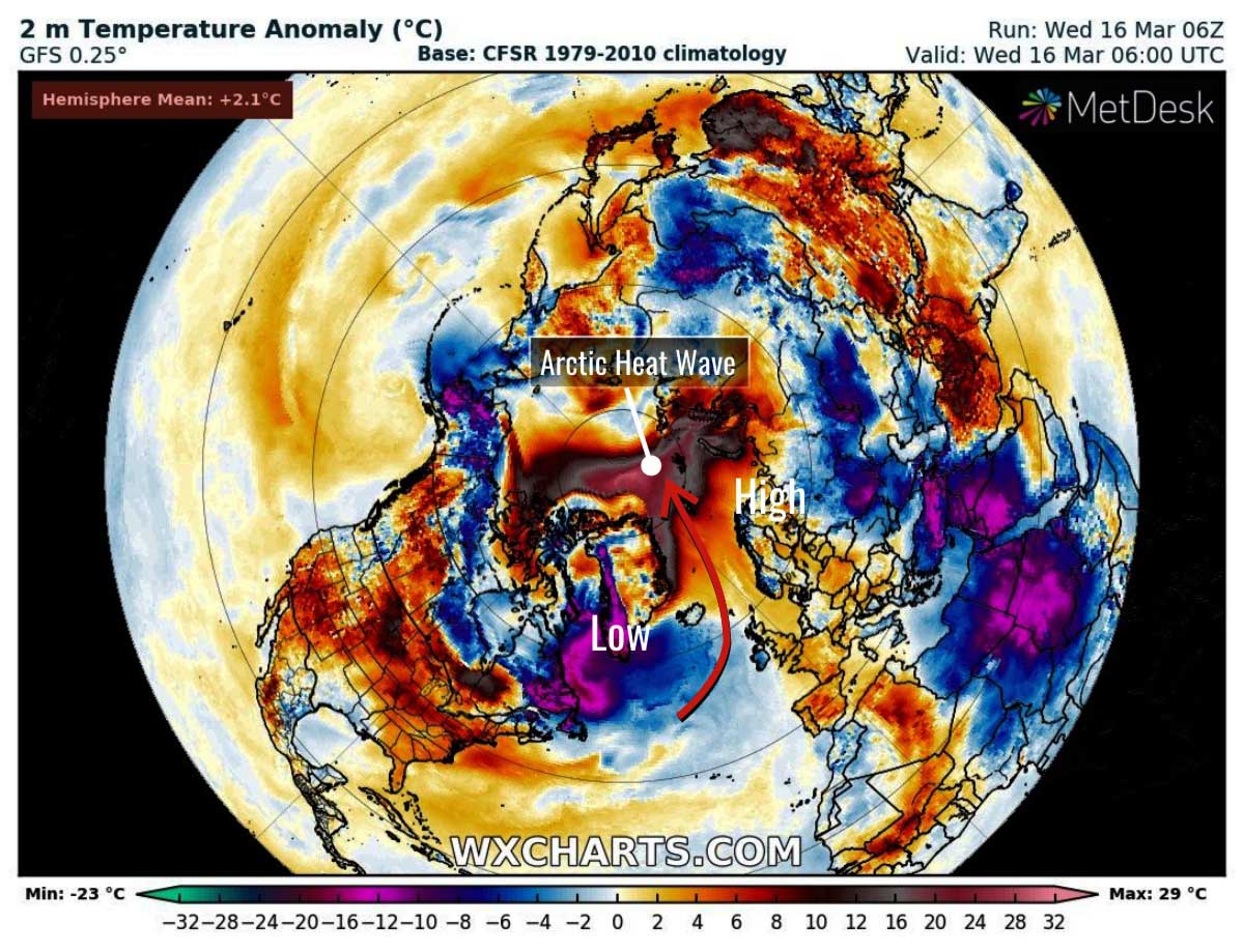
With a strong "heatwave" developing in the Arctic circle, surface temperatures reached up to 30°C above normal. Strong pressure systems in the sub-polar regions are creating a "wind tunnel" from the North Atlantic into the Arctic circle, funnelling warm air into the polar regions. The strong movement of air is creating unusual weather conditions both in and out of the polar regions.
16 March 2022 - Wed
Norway recorded a new maximum temperature of 3.9°C
The manned weather station Hopen in high Arctic Svalbard, Norway, measured a maximum temperature of 3.9°C. It was the highest temperature ever recorded at Hopen during March since observations began in November 1944. Unusually warm temperatures were also recorded in Greenland and the Russian archipelago of Franz Josef Land.
20 March 2022 - Sun
⭐️ Kyrios will attempt to arrest the sharp decline of Arctic sea ice extent caused by heatwave
Not only has the Arctic been experiencing a heatwave in recent days, the east Antarctic ice sheet is also facing a massive heatwave event, causing temperatures to soar 40°C above normal. The record-breaking heatwaves hitting both Antarctica and the Arctic simultaneously have shocked researchers, who warned that the "unprecedented" events could signal faster and abrupt climate breakdown.
Alarmed by the unusually high temperatures, Kyrios attempts to arrest the situation of the fast declining Arctic sea ice by bringing more snowfall to the region to stabilise ice in the Arctic. As such, Kyrios' Arctic ice intervention, originally scheduled to finish at the end of March 2022, may extend into April 2022 to curb and reverse the impact that the heatwave has on Arctic sea ice.
At the same time in East Antarctica, Kyrios is also helping to dissipate the heat accumulated as a result of the heatwave by shifting away the clouds and water vapour that was causing heat to be trapped.
31 March 2022 - Thu
Kyrios' 2021/2022 Arctic intervention comes to a close
After 7-month long efforts to boost Arctic ice in spite of rising carbon emissions and global temperatures, Kyrios' intervention has been nothing short of spectacular, producing an evident increase in Arctic ice levels corroborated by satellite data and on the ground observations.
Since intervention commenced in August 2021, Arctic sea ice volume has surpassed levels of the past 2 years, contradicting the downward trend observed in recent years. It has also increased to levels within the 2004-2013 interdecile range (i.e., it is within the normal sea ice inter-annual variability) – a situation that has not been seen since June 2019. Coincidentally (or not), it was also in 2019 and 2020 that forest fires around the world, especially around the Arctic circle, began to burn at an unprecedented scale, prompting Kyrios to step in to help put out the fires. A study noted that the loss in Arctic sea ice during autumn 2020 was driven by hot air sweeping in from Siberia while the region was engulfed in fires. It is for good reason that Kyrios often reiterates that humanity must protect our forests from burning as such fires can directly impact ice melt.

As for Arctic sea ice extent, it has grown at the fastest pace and to the largest extent in recent years. Between August 2021 to February 2022, Arctic sea ice extent had consistently remained at the upper boundary of the last 10 years' range, until a severe heatwave struck the Arctic in the middle of March.
Despite the strong heatwave, Arctic sea ice extent in March was only 3% (0.4 million km2) below the 1991-2020 average. This is the 8th lowest extent for March in the satellite record. The March extent continues a series of relatively small negative anomalies observed since July 2021, with values well above the record minima from the past two decades.

With atmospheric carbon dioxide now 50% higher than pre-industrial levels, it should be understandable that Kyrios' 2021/2022 Restoring Arctic Ice intervention could not have been to drastically restore ice levels to that of the pre-industrial era or the previous decades. Rather, Kyrios' intervention serves to arrest the declining trend of sea ice level, slow down ice melt and restore arctic ice progressively to ensure it does not worsen amidst current global warming conditions. Hence, to appreciate the positive impacts of Kyrios' intervention, this recent winter's sea ice levels should be compared with data from recent years on relative terms. Kyrios explains that a sudden and drastic increase in Arctic ice volume would have instead thrown the planet's climate systems into a state of disarray.
Kyrios' interventions bring hope to our Earth's climate crisis. However, anthropogenic causes of climate change such as the burning of fossil fuels, deforestation, livestock rearing and more persist. In this geopolitical climate, there are also risks of new wars and existing wars escalating into a nuclear war. Wars will devastate Earth's fragile systems and deepen our climate crisis. Climate scientists also warn that if humanity does not act fast enough to curb greenhouse gas emissions, we can only expect Earth's polar ice to shrink year after year, leading to more intense and frequent disasters around the world. Humanity is clearly facing an existential threat. Yet, many people remain unmoved by the obvious dangers ahead.
On 23 August 2021, when Kyrios made the bold statement to restore ice in the Arctic till March 2022, we anticipated positive news from the polar region and extraordinary climatic events to happen. Sure enough, many rare and unprecedented events ensued. The first was the dramatic turnaround of Greenland's massive summer ice melt loss when a rare "snowicane" delivered a vast amount of ice at the end of summer 2021. This was swiftly followed by reports of many record-breaking early winters and snowfall in countries in and around the Arctic Circle which quickly ramped up ice volumes across the region. Although the extreme weather may have caused inconveniences, Kyrios says that it was inevitable as more ice on land is needed to cool down not only the climate but also Earth's overheated core. Throughout this 2021/2022 Arctic winter, the polar vortex was also unusually active and strong, which helped to keep the Arctic region cold and aided in the rapid growth and support of the Arctic sea ice.
Through the observations and analysis from the scientific community and meteorological data, we were able to monitor, document and share how the intervention was carried out. To find out and understand more about how Kyrios achieved this phenomenal feat, catch the final episode of Restoring Arctic Ice (Part 4).

